The Registered Interests on Titled Land (RITL) concept is described as the visualization of interests present on a Alberta Land Title certificate which has a spatial reference including caveats, right of ways, restricted covenants and easements, discharges, surface rights and right of entry. These may be described spatially through a plan of survey, sketch plan, descriptive plan or through metes and bounds description. Essentially, it would tell you who own the facilities on a parcel of land.
This type of spatial data product has been needed and advocated for by the stakeholders at Alberta Data Partnerships (ADP) Stakeholder Sessions and External Advisory Group meetings since 2006. In 2017, ADP completed a Benchmark Project which proved the viability of the RITL mapping initiative. Following discussions with key stakeholders, including Municipal Affairs, a Discovery Report was completed in the summer of 2018 to address questions and concerns that arose, primarily around existing data sources and their applicability to the requirements that have been demonstrated by our stakeholders
The results of these reports clearly demonstrated the need for this data product and that there is no existing alternative that would meet the needs of ADP’s stakeholders for:
– Reducing duplication of data to significantly increase efficiency and drastically decrease cost for data compilation across all sectors;
– Visualization of interests on the land that does not currently exist for Titled Land and can facilitate simpler communication; and
– Broad access to a common, authoritative and accurate dataset that will improve engagement with stakeholders and partners.
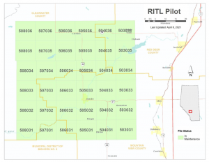
Following discussions with Municipal Affairs upon the completion of the Discovery Report, a Community Grant Agreement was completed and the Pilot Project kicked off in the Spring of 2019. The Sundre area (below) was chosen for the Project and mapping RITL data took place in 2020 and early 2021. The work included:
Total Title Mapped
10,842 (count includes those parcels with and without RITL interests)
Total distinct Registered Interests that are RITL types Mapped
19,983
Total distinct Registered Interests that are CAVE or UTRW types Mapped
18,516
Stakeholders were engaged throughout the process as part of an Advisory Committee that met throughout the project timeline. In addition, customers of Altalis were invited to participate in an online survey from February 24 – March 8, 2021 to share their business needs related to a RITL mapping data product. 133 respondents provided value feedback to the project.
Lessons learned (bolded) and recommendations coming out of the report include:
Mapping each title and associated interests individually in time/cost prohibitive
Recommendation: Map interests (i.e., well-site, pipeline, etc.) rather Title-based approach
Many Interests are not mappable
Recommendation: Focus on Caveats and Utility Rights of Way in initial phase
Acquiring Titles and associated documents were very time consuming (i.e., a few documents only available via fax, no bulk downloads)
Recommendation: Work with LTO to automate
Mapping all Interests from scratch is time/cost prohibitive
Recommendation: Engage with Land Surveying community to determine how to leverage existing data
Data must be available in a timely manner for maintenance
Recommendation: Work with AER to determine a method to access data as part of the OneStop regulatory process
ADP will be funding further projects based on some of the recommendations in order to determine the viability of a provincial-wide roll out.